Tuesday, October 30, 2012

Lava activity has slowed but is stable; from craters to coast

Above: Setting full moon looks like a big star with the fisheye lens I used for this pre-dawn photo of the coastal plains flow front early this morning.
I always like to these pahoehoe roping & banding breakouts. ~~~
That lens does exaggerate the flow front activity though; breakouts were small and sparse across a widespread area below the Pulama Pali and out towards the ocean a mile or so. The eastern edge is close to three miles from Kalapana Gardens. This front remains about a mile from the sea and is not advancing much at all these days; especially since the recent drop in magma pressures in Kilauea Volcano’s chambers.
You can see the ups & downs and stabilizing of these magma pressures on the USGS/HVO Deformation (magma deflation- inflation) graph
USGS/HVO has been reporting the lava level inside the summit crater dropped to about 175 feet below the Halema`uma`u crater floor but rose back to about 100 feet during these deflation-inflation periods. ~~~~~~~~~~~~~~~~~~~~~~~~~~~~~~~~~~~~~~~~~~~~~ And finally:
We had a treat last night as the full moon rose over Kalapana Gardens: Rain showers moved through and when the bright rising moon shone on them we got to witness a double rainbow. Or ‘night-bow’ as locals sometimes say.
~~~ Click on any image to open a new view window and larger sizes ~~~

Sunday, October 28, 2012

BC Canada earthquake triggers shoreline evacuations for Hawaii (And an eruption update)

As most of you would have heard by now, at 8:04 PM PST a powerful 7.7 earthquake with the shallow depth of 17.5 kilometers/11-miles, took place offshore of northern British Columbia, Canada.
The quake initially generated local tsunami warnings between southern Alaska down the coast to California as well as for the Hawaiian Islands; (I have family living in a houseboat on the outer west coast of BC, so was very concerned as the first reports were issued.).
Interestingly, there was never a Pacific-wide tsunami warning, only for Hawaii. The rationale for this appeared later in the evening when the Pacific Tsunami Warning Center geologists posted this amazing computer generated wave projection graphic (screen capture of meteorologist Guy Hagi on Hawaii News Now below):
The graphic shows the computer model projected a narrow thrust of quake waves across the Pacific Ocean and directly to the center of the Hawaii Island chain; hence the statewide evacuation orders for all coastal communities here in Hawaii. Below is the news reporting the projected wave-surge heights for Hawaii:
I live in one of those evacuation zones and the warning sirens began at around 7:30 PM local HS Time and repeated every half hour until 11:00 PM. No I did not evacuate; I was feeling quite safe at this particular location. ~~~ I was tempted, though, to drive to Hilo and set my camera up in some safe location where I could still see the Hilo Bay front and record any wave surge we might have. Hilo was one of the areas forecast to get the highest impact from any tsunami action. Hilo Bay has a record of devastation when it comes to these things. This time around there were reports of receding water that left moored boats high and dry for a few minutes. By 4:00 AM this morning all watches and warning related to this quake event were cancelled. ~~~~~~~~~~~~~~~~~~~~~~~~~~~~ ~~~~~~~~~~~~~~~~~~~~~~~~~~~~~~~~~~~~~~~~~~~~~~~~~~~~~~~~~~~~~~~~~~~~~~~~~~~~~~~~~~~~~
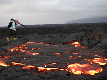
 ON THE LAVA FRONT
Above: The Halema`uma`u Crater at dusk showing high lava levels this week; Courtesy of USGS/HVO. ~~~~~~~ We had an exciting week here actually. Molten lava levels within the active vent on the floor of Kilauea Volcano Halema`uma`u crater rose even higher than my last blog posting of 125 feet (lava lake to crater floor brim). The highest level reported by USGS/HVO reached 89-feet a few days ago, then deflation of the magma reservoirs occurred sharply, lowering the lava a bit and halting the rise as shown in the graphic below:
During these past weeks of rising lava levels there has been increased local earthquake action; particularly in one area southeast of the summit crater, down the Chain of Craters road a little ways toward the coast:
~~~~~~~~~ And lastly, the photo below is one I took a couple nights ago from Kalapana Gardens. It looks like daytime because there was a nearly full moon and I overexposed the image to bring out both the lava glow activity on the Pulama Pali and coastal plains, which can be seen best in the larger image size. That cloud hung up there for most of the night as winds ceased in all directions for a while in between weather systems.
~~~~~~~~~~~~~~~~ Click on any image for a new window for a larger view size of all images ~~~~~~~~~~~~~~~ Meanwhile I am fascinated to watch the incredibly massive & powerful storm system approaching the US Atlantic coastline right now—The weather systems meeting up in that region look to have the makings of severe damage over a very wide area. The satellite imagery linked (tools & data) on the National Hurricane Center website really shows just how huge and widespread this hurricane has become. I am hoping all of you in that region are out of harms way.

Monday, October 22, 2012

Kilauea’s Halema`uma`u crater lava lake all time high level

It was back on March 19, 2008 when the Halema`uma`u crater floor had a small explosion creating an open hole down to the raw lava that connects to the massive magma chambers below Kilauea volcano; a crater within the crater. As I remember, the original vent hole was about 162 feet across and the molten lava was something like 800 feet below the floor of the crater. In the four and a half years since then, rises and falls of the broiling lake of lava inside the vent have steadily eroded the walls of the vent; widening it to 520 feet/160 m, in diameter. As well, lava levels have slowly risen and tending to maintain higher levels; currently around 165 feet below the main crater floor rim.
Above: USGS/HVO aerial image showing high molten lava lake level. Saturday, October 20, the USGS reported a brief rise of lava to 125 feet/38 meters below Halema`uma`u crater’s floor, as shown in a recent image they posted on this webpage. USGS Hawaiian Volcano Observatory expressed in a media release that if the lava lake reaches 65 feet below the crater floor rim, then it would be visible to the public from the parks observatory. Yesterday, in a local radio report, Dr. Jim Kauahikaua, HVO’s Scientist-in-Charge, voiced the possibility of this lava lake either breaching onto the main crater floor or creating an eruption in the Kilauea region between Halema`uma`u and Pu`u O`o craters; based on historical patters such as earthquake increases and magma conduit obstructions along with the high lava levels within the summit crater. That prospect is exciting! Big Island Video News posted a great report on these changing lava lake levels using USGS/HVO video: ~~~~~ Meanwhile: lava continues with small breakouts and inflation across a wide area of the coastal plains below the Pulama Pali; as well as tube breakouts above the pali.
Click on any image to open all these photos in a large view window.
After dark some of these molten breakouts can be seen from the lava viewing area next to Kalapana Gardens (2:00PM to 10:00PM.

Saturday, October 13, 2012

Large area of crusting lava on the coastal plains; diminishing advancement

Above: pre-dawn light on the coastal plains flow front, and below looking east with Venus & crescent moon rising. (Click on any of these pictures to open a larger size view window of all images)
~~~~~~~~~~~~ As of early this morning large sprawling areas of the recent coastal plains lava flows were stagnating but still inflating and random little breakouts all over, as well as a small breakouts far up the pali. These photos and captions tell the story~~
~~~~~~~~~~~~~ Above and below shots are that ropy pahoehoe~~
~~~~~~~~~~~~~ Below: Large cracks forming as strong inflation pushes from beneath from molten lava continuing to surge into the area from sources about six miles northwest; the Pu`u O`o crater and Kilauea east rift zone.
~~~~~~~~~~~~~~~~
Closer look at a fresh surge of pahoehoe. ~~~~~~~~ And finally,below, this was the view from Kalapana Gardens at 3:20 AM this morning (not much to see really); the lava coming down the Pulama Pali, four miles distant, has crusted over and formed tubes that now deliver the molten rock onto the coastal plains. (We cannot see the coastal lava from here). The lava is still over one mile away from the ocean, and at the current rate & stagnation levels, it may be some time before it reaches the sea, if at all. Lava was last entering the ocean December 31st, 2011.

Monday, October 1, 2012

Molten lava front pushing down the Pulama Pali

Above: the view from within Kalapana Gardens subdivision last night; the same view seen from the Hawaii County Lava viewing Area (located off the terminus of highway 130). The flow front is at around the 1000-foot/300-meter elevation and four miles distant.
Hundreds of yards/meters across, a wide and sprawling front of mostly pahoehoe type of lava with some small sections of the rough and jumbly A`a, are re-covering older lava as well as taking yet another slice out of the tattered remnants of the abandoned Royal Gardens subdivision kipuka forests.
Here are a few other photos I recorded a couple days ago at the flow front on the full moon; the last image is that full moon setting overtop the advancing lava.(Click on any image to open them all into a larger viewing window)
~~~~~~~~~~~~~~
~~~~~~~~~~~~
~~~~~~~~~~~