Friday, February 25, 2011

~ Pulama Pali up close ~

Above - Pulama Pali breakouts at the about the 700-foot elevation at daybreak this morning.

I have been wondering why the numerous scattered surface flow breakouts we have been seeing in a broad swath trailing down the Pulama Pali have not advanced makai (toward the sea) very much over the past week. During the five days of prolonged deflation we could expect things to slow down, but we had a day of strong inflation since then and steady pressure afterwards, so I thought that might get lava moving faster down the pali.

To find out what was really going on up there I hiked all around the slope between the 600 to 900-foot elevation this morning; the lava up there is in fact advancing but is also doing a lot of inflating into mounds resembling bee-hives of piled glowing lava with many breakouts surrounding them. The image above and following photos show what I saw:
Pre-dawn light.

Below-- Eastern edge of the pali flow at around the 500 foot elevation:Below: Four hundred foot elevation with Kalapana Gardens homes in in the distance. Lava flowing down this eastern edge is overtopping the previous flow of November-January. It is also crossing over the 1986 and 1990 flows that lay just west of that large kipuka we see in the background of both these images. There continues to be surface lava breakouts further down slope quite a ways from here. Those lower flows are generally in the same area they have been active for a couple of weeks. That area also is not advancing much, but is still quite active and accessible to the many new guided tour outfits. (Scroll below to my last few posts to see those surface flows)

Molten mounds all over at the 800 to 900-foot elevation.

Lava continues being very active within both the Halemaumau and Pu`u O`o craters. I have been watching the USGS/HVO web cams day and night. The Pu`u O`o crater floor was flowing with lava rivers last night.

Tuesday, February 22, 2011

~ Pulama Pali slopes look like a city of red orbs after dark ~

As viewed from the end of the Kalapana Gardens access road, which is also the Hawaii County lava-viewing road, visitors to the area are able to quite easily see many distant lava breakouts scattered across the Pulama Pali looking very much like a magic city of red-orange orbs. (Twice I went to get a photo of this and the rains arrived and dampened that effort).

Lower down the slopes at the base of the pali and closer to the viewing road there are also continued small & scattered surface flows of lava. These are in the same general area as in my last two post updates - still over 3500-feet from the road. I have not hiked back out there since then but will do so very soon for a firsthand account.Courtesy photos from Ron Boyle that he took in this area yesterday.

The remarkable thing about these ongoing surface flows is they have maintained a pretty strong presence despite the largest drop in magma pressures beneath Kilauea Volcano since the year 2000, according to USGS/HVO deformation records. Normally a substantial pressure drop manifests in the eruptive lava fields as diminished activity.

Even the two craters continued showing strong activity much of the past week during deflation, though the highly active flows within the Pu`u O`o crater finally did slow way down in the past couple of days.

As these two graphs show, magma pressures finally did return last night beneath both craters. I am very interested to see how this inflation will affect an already active flow field and the two craters… Could become quite active, especially if the inflation becomes strong.The above graph is from two days ago, Feb 20, before hitting bottom last night, as shown in today's graph below. Notice how they drastically changed the scale on the graphs to accommodate the large recorded swing: USGS/HVO magma pressure deformation tiltmeter graphs

Last week I added a link to one of my posts that may have been missed by some of you because it was added later. The link is to Big Island Video News and contains my bi-weekly Kalapana lava field report. My report is 2-minutes long and starts at the 1:22-minute mark of the news report. It has a lot of action clips of the lava pouring into the sea and on the surface of the area I report in these blog updates. You can watch the video report HERE.

~~~~~~~~~~~~~~~~~~~~~~~~~~~~~~~~~~~~~~~~~~~~~~~~~~~

As usual these past few weeks;
I will try to post my next update in a few days unless some more exciting lava developments take place in the meantime ;)

You can always get onsite coastal lava flow information and viewing conditions by phoning Janguard lava viewing security management who are stationed along the access road at the end of Highway 130 from 2:00 PM until 10:00 PM daily: 430-1966

Friday, February 18, 2011

~ Coastal plain surface lava continues spreading and partially reoccupying older tubes ~

At sunrise, tour group lead by a local Kalapana Gardens resident takes in the sporadic surface lava breakouts. The Gardens and open ocean can be seen in the distance. The closest homes are still over 4000-ft away.

Above & below: Compared to where the lava was advancing to the east on February 15th, much of that eastern finger surface lava has stalled. There is, however, some new breakouts starting up just west of there this morning, and beginning to return to the brushy area it had previously passed along side of.

The surface lava continues moving south-southeast further below the kipuka seen burning in my last post.
But quite separate from these two flows is a third area much further south where molten lava is surging hotter and faster than the upper regions. The area I am talking about is very near the original July 2010 lava flow tube system and about 4000-ft southwest from the end of the road and maybe 2000-ft south from the above-mentioned kipuka… It’s hard to describe a spot in the middle of a vast uneven lavascape! … Anyway, I think this flow front may become the dominant one of the three. Perhaps reaching the ocean in the days ahead…
I think some of the older lava tubes that were feeding the east entry are being partially re-energized by the new lava coming down onto the coast now.

… Speaking of ocean lava, this morning at sunrise there was suddenly a burst of steam from the coast. This was located at the most recent lava site we refereed to as the east ocean entry. I hiked out there but by then there was only a small amount of steam and I could not spot any molten lava.

On the way out to check that entry I came across more downed mango trees from when the lava came through a coastal kipuka forest last month.

Wild swings of magma pressure beneath Kilauea Volcano have been taking place this past week-- and the tiltemeters recorded a substantial drop in pressure in the past day:

USGS reports: Since Kilauea's summit vent first opened in Halemaumau Crater on March 19, 2008, it has grown from about 35 m (115 ft) to almost 150 m (490 ft) in diameter.

Check out this movie clip of a massive rockfall, the second of two on February 14th and there was another on the 15th.

Many other intresting movie clips and photos on this USGS Images page; including some spectacular new footage today of the lava rivers inside the Pu`u O`o crater--- things are really heating up in there these past few weeks! Click the highlighted text to open the links.

~~~~~~~~~~~~~~~~~~~~~~~~~~~~~~~~~~~~~~~~~~~~~~~~

I will try to post my next update in a few days unless some more exciting lava developments take place in the meantime ;)

You can always get onsite coastal lava flow information and viewing conditions by phoning Janguard lava viewing security management who are stationed along the access road at the end of Highway 130 from 2:00 PM until 10:00 PM daily: 430-1966

Tuesday, February 15, 2011

~ Coastal flats lava still advancing ~


Pre-dawn this morning: looking from the eastern flow front to the north - up the Pulama Pali. The pali hosts numerous breakouts from top to bottom.

This eastern front of lava has advanced about 1000 feet in two main branches over the past five days. This surface lava is overtopping the November-December 2010 flow and has also continued skirting along its eastern border, with one sprawling finger heading due east over older flow fields a couple of hundred feet and scorching some small patches of grass & brush.

Above: Dawn this morning looking down one finger of lava that is flowing east. The leading edges of the eastern lobe of surface lava are now due east 2,700-feet away from the present terminus of Highway 130, which is also the Hawaii County Civil Defense lava viewing area. The nearest home to the molten lava is currently 3,700 east. Much of this surface lava is filling low areas and somewhat hidden from view when looking from those homes in the Kalapana Gardens area.

Both the Halema’uma’u an Pu`u O`o crater remain extra active. The Pu`u O`o has molten lava rivers running on the crater’s floor. This activity could be seen on the crater's webcam yesterday and last night. Below is a capture off that cam: And better yet, if you have a few minutes check out this USGS Quicktime movie made from a series of Pu`u `o crater still photos from Feb. 6th to 8th HERE.

~~~~~~~~~~~~~~~~~~~~~~~~~~~~~~~~~~~~~~~~~~~~~~~~

I will try to post my next update in a few days unless some more exciting lava developments take place in the meantime ;)

You can always get onsite coastal lava flow information and viewing conditions by phoning Janguard lava viewing security management who are stationed along the access road at the end of Highway 130 from 2:00 PM until 10:00 PM daily: 430-1966

Saturday, February 12, 2011

~ Stirrings beneath Kilauea ~

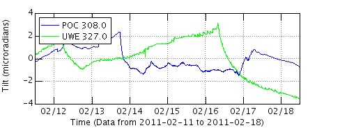
Kilauea Volcanoes summit, Pu`u O`o crater and the adjacent rifts have been registering some very notable changes. Those of you who have also been following the US Geological Survey (USGS) -- Hawaiian Volcano Observatory (HVO) daily website updates, and their associated informative links, will already be alerted to some significant new developments.

I do not intend to mirror what the USGS/HVO is doing; in fact I am suggesting we all keep reading their updates.

The main notable volcano changes have been:
-- More frequent and higher ‘stands’ of molten lava rising inside the Halema’uma’u craters pit-vent – along with longer lasting high levels. In the past 24 hours one stand reached to within 235-ft (72-m) of the main crater floor - much higher than any previous levels. At one time the base level was closer to 660 feet down. A more recent base, or resting level, has been closer to 435 ft, but the ‘base’ seems to be continually rising as the months go by. The pit vent is about 460 ft (140 m) in diameter at the top (growing wider each month), and around 150 ft (65 m) at the bottom. Background tremor has been notably higher between stands they report.

-- An escalation of earthquakes in the Kilauea region is being recorded by the vast array of seismographs; 40 quakes in 24-hours two days ago; with one as strong as 3.8 in magnitude, and 24 temblors in the past day. Seismologists become very alert to such changes because a rise in quake action can, and has in the past, indicated significant eruptive events.

-- Pu`u O`o crater, 12-miles (25 km) to the east-southeast of the summit, has also been experiencing a heightened eruptive cycle: Molten lava rivers and lakes and building spatter cones within the crater, along with increased temblors. These events have been somewhat intermittent but are significant crater building characteristics.

-- Increased Thanksgiving Eve Breakout (TEB) eruptive site activity:
This site and the rootless shield area makai (toward the sea) from it have been very active with surface flows of lava. A week ago some of these breakouts interrupted the newly established lava tube system feeding the coastal flats and ocean entries. There has also been an increase in recorded earthquakes in that higher elevaton area as well.

The finer nuances of these changes to the volcano action can be better understood by reading the USGS reports and related links.Shown above; during high-lava-stands the degassing fumes diminish greatly, as do the levels of glow at night. But in between these stands glow has been extra bright lately. Check out all the USGS web cams day and night here


Meanwhile, down along the coastal flats lava continues to slowly advance through two forest patch remnants (kipuka) at about the 130 to 200-ft elevation. Surface flows also move further down and along side of the most recent flow that we had there a few months back; in November and December. Some of the lava branches have stalled. This molten lava advance is still approximately 4,800 ft from any homes and is not moving directly toward them, but has been angling that way as it goes. There has been no reports of lava flowing into the sea since it ceased at two locations a week ago.

See my video footage of this weeks lava flow in my lava field report for Big Island Video News. My report comes in the 2nd-half; after their take on the recent Kilauea changes. Click the highlighted text to open the reports.

~~~ I will add updates as activity warrants. ~~~

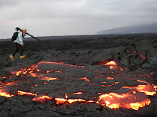
Just cooling - roping and banding pahoehoe. Photo taken February 10, 2011 at the new advancing lava flow near Kalapana Gardens. ((By the way, all images posted on this website are copyright of Leigh Hilbert Photography unless otherwise labeled. I reserve all rights to them. Permissions or license to use my images in any form must be from me in writing.))

Thursday, February 10, 2011

~ New surface flow reaching the coastal flats ~

Another surge of molten lava has been working downhill near the base of the Pulama Pali. As my last post indicated, lava had all but stopped flowing in the coastal area a few days ago. Likely due to some serious eruptive breakouts high above the pali around the TEB vents and nearby rootless shield range, which may have drawn the coastal lava flow dry, or severed the previous Nov 29th 2010 to February 6th 2011 flow tubes.

The pali and coast plains have numerous breakouts. The most southeasterly flow front – its eastern edge – is presently 3,500 feet due west of the latest location of the Hawaii Civil Defense barricades; the terminus of Highway 130.

The new flow has just burned through the same kipuka that the previous flow went through in early-to-mid December 2010. The lava front is now beyond the patch of forest, as shown in these photos, and is overtopping the last flow, which is still red-hot inside.

As usual, the advancing lava is filling low areas. Some fingers of the front are breaking more easterly onto old lava from the mid-80’ to 1990. This kind of movement could potentially pose a new threat to the Kalapana Gardens homes once again.

All photos were taken this morning, click to view a larger size.

Meanwhile, down along the distant coastline as seen from the flow front mauka, I could see lots of fumes and three separate whispers of steam where the last ocean entry lava recently poured. I believe the steam is likely ocean waves hitting the still hot lava benches, though some left over lava tube dribbles may be finding the sea. Sunrise over Kalapana Gardens
~~~~~~~~~~~~~~~~~~~~~~~~~~~~~~~~~~~~~~~~~~~~~~~~~
I will post my next update as soon as eruptive conditions on the coastal plain have changed, or if other significant volcano news takes place.

Onsite coastal lava flow information and viewing conditions can be found by phoning Janguard lava viewing security management who are stationed along the access road at the end of Highway 130 from 2:00 PM until 10:00 PM daily: 430-1966

Sunday, February 6, 2011

~ Most surface flows stopped - and only weak ocean entries ~

(Click the images for larger view sizes)
Two visitors to the island were with their guide, who is out of frame, are watching some small surface flows near the ocean as the sun rises. This was at the far western lobe ocean entry Sunday morning.

Just two days ago we were witnessing some very large surface flows of lava across the coastal plains west of Kalapana. By Sunday nearly all breakouts had crusted over.

Even the two ocean entries were very subdued. I did not hike out to the eastern entry but I could see a feeble steam way off in the distance.
There has been no pronounced magma chamber deflation to account for the sudden drop in coastal activity, but according to USGS lava updates, there have been heightened surface flows high above the Pulama Pali and inside the Pu`u O`o crater the past few days (The Pu`u O’o quieted for a day but was flowing with lava rivers again at 8:00 PM Sunday night). Maybe the lava tubes leading to the sea have been partially severed.


For the first time in a year or more I hiked inland and west from the coast for a few miles. I was surprised just how extensive the recent lava flows have become; miles of the coastal plains have molten lava laying a short ways below the crusted surface. I would love to see a new USGS thermal/aerial overlay of the entire coastal plains.

One surprise I spotted was what appeared to be degassing fumes far to the west of Kalapana Gardens – all the way into the Hawaii Volcanoes National Park. Though I was still quite a ways off, these fuming lines ran from near the western base of the Pulama Pali all the way southwest to what seemed to be a possible ocean entry plume…. I have heard of no other reports of any activity down that way, so maybe it was an early morning anomaly of fumes. Below is a rough composite of three shots showing the fumes in question in the distance. Click on the image if you want to see it larger.


USGS has posted some new flow-field maps. Below are the maps, click the link above for the captions on their site.

~~~~~~~~~~~~~~~~~~~~~

I will post my next update as soon as eruptive conditions on the coastal plain have changed, or if other significant volcano news takes place.

Onsite coastal lava flow information and viewing conditions can be found by phoning Janguard lava viewing security management who are stationed along the access road at the end of Highway 130 from 2:00 PM until 10:00 PM daily: 430-1966

Friday, February 4, 2011

~ Western ocean entries back to life ~ Pu`u O`o very active ~

Perhaps due to the recent increase of magma pressures beneath the Kilauea Caldera, which are leveling off now, a resurgence of surface lava has occurred along the more western lobes of coastal lava flows from the December advancement. The result is numerous new ocean entries near the sea arch where lava was flowing about three weeks ago. Ron Boyle documented the event yesterday and has kindly submitted his images for the blog.
Lava flowing above the western ocean entry.


The easterly ocean entry and surface flows out on the west-end of the July 25-Dec 1, 2010 lava delta also continue, as posted previously.

Random surface lava breakouts continue across the coastal flats west of the terminus of the highway – the Hawaii County Civil Defense lava-viewing site. To the West-northwest there is more kipuka forest and brush burning from a small breakout. The Pulama Pali also continues exhibiting scattered surface flows that are easily seen after dark. No homes southeast or east of these flows appeared threatened as of 10:00 PM last night.

USGS crater cam continue recording a very active Pu`u O`o crater floor with spewing cone and molten lava rivers. Check out the cam even now and see it changing by the hour; at night it is lit up with lava flows too. Below is a rough composite of this mornings crater images:Notice the growing spatter-cone in the center.

Last night, as seen often lately, the Halema’uma’u crater cam as viewed from the Jaggar Museum was recording very pronounced glow from the broiling lava lake that has been rising and falling from around 435-feet down inside the pit vent to recently as high as 330 (100 meters) from the main crater floor according to the USGS volcano updates. The Halema’uma’u overlook cam looks straight down inside the vent and here is a cam-capture from this morning of that:All the USGS-HVO webcams can be found HERE

I will post my next update as soon as eruptive conditions on the coastal plain have changed, or if other significant volcano news takes place.

Onsite coastal lava flow information and viewing conditions can be found by phoning Janguard lava viewing security management who are stationed along the access road at the end of Highway 130 from 2:00 PM until 10:00 PM daily: 430-1966

Wednesday, February 2, 2011

~ Magma pressure rises ~ Lava active in craters and on coast ~


Tiltmeters are registering a significant up-tick on the USGS deformation graphs.

Except for a one brief drop, magma pressures have been on the rise this past week. This is the most pronounced increase for quite some time.

A defined and sustained rise or fall of magma pressures has often translated within the eruption sites with an increase or decrease I activity respectively. Last night I took a look at the webcams for the Halema`uma`u from HVO, the Halema`uma`u from Overlook, and the cam looking into the Pu`u O`o crater. All three sites were very bright with lava glow, signaling heightened activity.

Down the Pulama Pali, across the coastal plains and along the shoreline adjacent to Kalapana Gardens and vicinity, lava continues beneath ground; flowing and moving within insulating crusts and tubes. In random locations lava breaks out from these underground conduits and reveals itself on the surface: covering other recent flows, filling low areas, burning brush or trees, and flowing into the ocean.

Perhaps due to this current inflation of magma pressures there was a bright surface glow high atop the Pulama Pali last night and an increase of scattered surface flows on the coastal plains, including areas off the end of highway 130 (originally named Kaimu-Chain of craters Road). I will take look at conditions today and tonight.