THE HIGH SURF WARNING IS NOW IN EFFECT FROM NOON TODAY TO 6 PM HST FRIDAY.
* SURF...PEAK SURF HEIGHTS OF 35 TO 40 FEET ALONG NORTH FACING SHORES...WITH PEAK SURF HEIGHTS OF 25 TO 35 FEET ALONG WEST FACING SHORES.
* TIMING...SURF WILL BUILD THIS AFTERNOON AND TONIGHT...PEAKING EARLY THURSDAY ON KAUAI AND OAHU...AND PEAKING DURING THE DAY THURSDAY ON MAUI. THE SWELL WILL REMAIN LARGE THROUGH AT LEAST FRIDAY.
* IMPACTS...DAMAGING SURF IS EXPECTED. LARGE WAVES WILL IMPACT THE NORTH AND WEST FACING SHORES...WITH COASTAL EROSION AND WAVE RUN-UP POSSIBLE IN COASTAL AREAS EXPOSED TO THE SWELL.
These size of waves and their duration have made it likely we will hold the infamous Eddie Aikau Quicksilver surfing competitions in the next two days. Here is CNN’s report on that.
Mauna Kea webcams have time-lapse images showing the snow coming and going. Here is one of them.
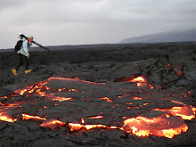
Meanwhile the lava continues flowing despite the weather.
 The lavascape above was the scene at forests edge and three hundred feet from the ocean yesterday morning. Click the image for a larger size. The surface flows here are actually now running out overtop the delta bench formed during the July 25th to December 1st ocean entry event.
Below is the same area in the pre-dawn light:

I never tire of the endless art form designs created while pahoehoe flows then cools - here are two photos I took yesterday of the still hot lava:


No comments:
Post a Comment